Watch FIFA World Cup 2026™

LIVE, FREE and EXCLUSIVE

Ex-tropical cyclone Penny to bring heavy rain, damaging winds to Queensland

Severe weather is on its way to Far North Queensland today as ex-tropical cyclone Penny approaches the coast with a possibility it could grow stronger.

Ex-tropical cyclone Penny expected to bring heavy rain and potentially damaging winds to parts of the Queensland.
Ex-tropical cyclone Penny expected to bring heavy rain and potentially damaging winds to parts of the Queensland. Source: Bureau of Meteorology

Wild winds and heavy rain are on their way to Far North Queensland as a tropical low heads for the coast.

There is a chance the low, which is former cyclone Penny, could re-intensify to cyclone strength but the most likely scenario is that it will cross the coast as a low, the Bureau of Meteorology says.

"Either way, heavy rainfall and damaging winds will be the main impacts," BOM weather services manager Richard Wardle said.

The weather conditions are expected as early as midnight, continuing into Wednesday morning. 

News that makes sense

Your trusted source for staying up-to-date with the world around you. Get free daily news updates and analysis, straight to your inbox.

By subscribing, you agree to SBS’s terms of service and privacy policy including receiving email updates from SBS.

"Based on the current forecast track, Penny is set to move onto the Queensland east coast during Wednesday morning, but the scenario of it crossing as early as tonight cannot be ruled out," the Bureau of Meteorology said in an alert. 

A severe weather warning is in place for coastal regions between Alva Beach and Sarina where winds and heavy rainfall may lead to flash flooding.

The forecast path of the low-pressure system that was Cyclone Penny.
The forecast path of the low-pressure system that was Cyclone Penny. Source: Bureau of Meteorology

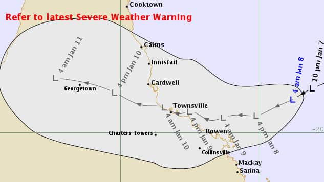
Heavy rain will initially develop around coastal regions from Tuesday with isolated falls of more than 200mm possible.

Wind peak gusts of around 90 kilometres an hour may develop over the Whitsunday Islands as early as Monday night.

The bureau has issued a new Flood Watch for coastal catchments from St Lawrence to Cape Tribulation including the Mackay, Townsville and Cairns.


2 min read

Published

Updated


Share this with family and friends


Get SBS News straight to your inbox

Sign up now for daily news from Australia and around the world. You can also subscribe to Insight's weekly newsletter for in-depth features and first-person stories.

By subscribing, you agree to SBS’s terms of service and privacy policy including receiving email updates from SBS.

Follow SBS News

Download our apps

Listen to our podcasts

Get the latest with our News podcasts on your favourite podcast apps.

Watch on SBS

SBS World News

Take a global view with Australia's most comprehensive world news service

Stream now

Watch the latest news videos from Australia and across the world