
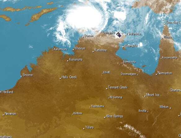
Tropical Cyclone Marcus is forming off the Top End, with storm tides, damaging waves and flooding to hit land by Friday night.
Marcus is likely to make landfall at Croker Island about 9.30pm on Friday before crossing the Cobourg Peninsula and passing through Darwin on Saturday, the Bureau of Meteorology said.
"It will be in the early hours of Saturday morning we see the cyclone impact on Darwin and it is a category one system which means we can expect to see winds of up to 100km/h plus," bureau spokeswoman Jude Scott said.
Heavy rains mean Darwin could also receive around 200 millimetres over 24 hours.
People should stay away from beaches and coastal areas due to expected higher than normal tides, NT emergency services spokesman Warren Jackson said.
News that makes sense
Your trusted source for staying up-to-date with the world around you. Get free daily news updates and analysis, straight to your inbox.
"The increased rain in the area could also cause localised flash flooding, so we're reminding motorists, to 'turn around, don't drown," he said.
Residents were warned to take precautions, while the Tiwi Island Football League cancelled its grand final on Sunday.
Saturday's Palmerston council election may also be postponed.
The bureau warned the islands would be the first impacted on Friday and that people should stay indoors.
"The islands should begin to experience squally weather later today (Friday) and we can expect similar in Darwin as the intensifying tropical low moves south," Mr Jackson said.
Marcus could also impact Western Australia with the northern Kimberley region likely to receive rainfall of between 50mm and 150mm
The cyclone is expected to move into the Timor Sea later on Saturday or early Sunday.
