


What is a tropical cyclone?
Tropical cyclones are intense low-pressure systems that form over warm ocean waters at low latitudes.
They form when the sea-surface temperature is above 26.5C, drawing their energy from warm tropical waters.
Cyclones produce gales, torrential rain and storm surges of varying intensity, depending on how low the storm's central pressure becomes.
Tropical Cyclone Marcus
News that makes sense
Your trusted source for staying up-to-date with the world around you. Get free daily news updates and analysis, straight to your inbox.
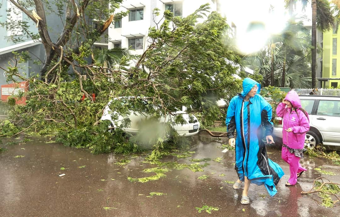
Residents in the Top End are still cleaning up after Tropical Cyclone Marcus wreacked havoc last week.
Winds up to 130km/h brought down trees and power lines in Darwin as the cyclone swept through the city.
Senator Nigel Scullion told federal parliament on Monday that "as you can imagine the tropical cyclone has left behind a path of destruction in the greater Darwin region."
"It is a very difficult time. I urge all Territorians to be patient and calm as authorities co-ordinate the clean-up effort and I encourage everyone to give each other a hand," he said.
Marcus then passed off the coast of far-north Western Australia and intensified.
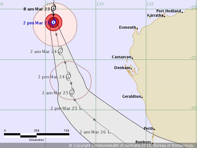
But according to the latest information from the Bureau of Meteorology (BOM), Marcus "is (now) weakening as it moves southward, well away from the WA mainland".
"Marcus will continue moving generally southward and weaken further during Friday and Saturday. Marcus will weaken below tropical cyclone intensity late Saturday or early Sunday, well off the west coast of WA."
Tropical Cyclone Nora
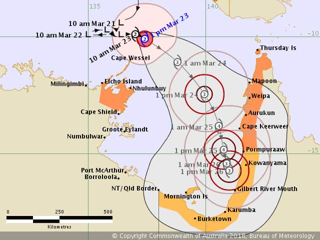
As of Friday afternoon, Cyclone Nora is forecast to intensify into a category four storm as it moves towards Cape York with heavy rain and winds gusting up to 170km/h expected.
Nora is rapidly intensifying off the Northern Territory coastline and the unpredictable system is expected to make landfall on Saturday or Sunday on Queensland's northwestern coast.
Extra police officers were rushing to remote Cape York communities on Friday while cyclone preparations are already in full swing.
Minor flooding is likely to occur from the Cape possibly down to Townsville and authorities are also warning people to beware of tidal surging as Nora approaches.
No cyclone has crossed the coast in the forecast area since 2001 but Queensland Premier Annastacia Palaszczuk is happy with preparations.
Senior officers from swift water rescue crews and SES leaders have been deployed to remote communities and Ms Palaszczuk said regional mayors would be updated every three hours.
"A category four is a big system. A category four is intense, and it's the tidal surge that comes afterwards," she said.
Queensland Bureau of Meteorology manager Bruce Gunn said flood watches were in place as up to 200mm of rain could fall daily with isolated pockets possibly being hit with 300mm.
Nora, located about 560km northwest of Weipa on Friday afternoon, is forecast to hang around the southern part of the Gulf of Carpentaria for days but may dissipate to a category three cyclone before crossing the coast.
If it reaches category three, wind speeds will escalate to 165-224km/h, strong enough to cause roof and structural damage if it crosses the coast in a populated area.
The Northern Territory is also on cyclone footing.
Two more in the region?
Bureau of Meteorology forecaster Jonathan How told the ABC on Friday that there was slim chance a tropical low towards the Coral Sea could become a tropical cyclone.
"We can't rule it out, but it looks like there will be generally unfavourable conditions for the system developing," Mr How said.
He also told the national broadcaster "some of the models are suggesting" another developing tropical low further to the north west in the Indian Ocean could spin into a cyclone.
"(But) it's not expected to have any impact on the continent," Mr How said.
Cyclone season
According to the BOM, the tropical cyclone season runs from November 1 to April 30.
BOM material says that "on average, there are 10 to 13 tropical cyclones each season in the Australian region, four of which typically cross the coast".
"Cyclone formation is rarely spread evenly throughout the season; often quiet periods are followed by bursts of activity."
There have so far been seven tropical cyclones in the area this season - with Marcus being the strongest.
The BOM provides an extensive Surviving Cyclones: Preparation and Safety Procedures information page.
Additional reporting: Nick Baker
