


Experts say Australia's bushfire season is "particularly tricky" to forecast this summer, with competing climate forces pulling weather conditions in opposite directions.
In late November, the National Council for Fire and Emergency Services (AFAC) released its bushfire outlook for the 2025-26 summer.
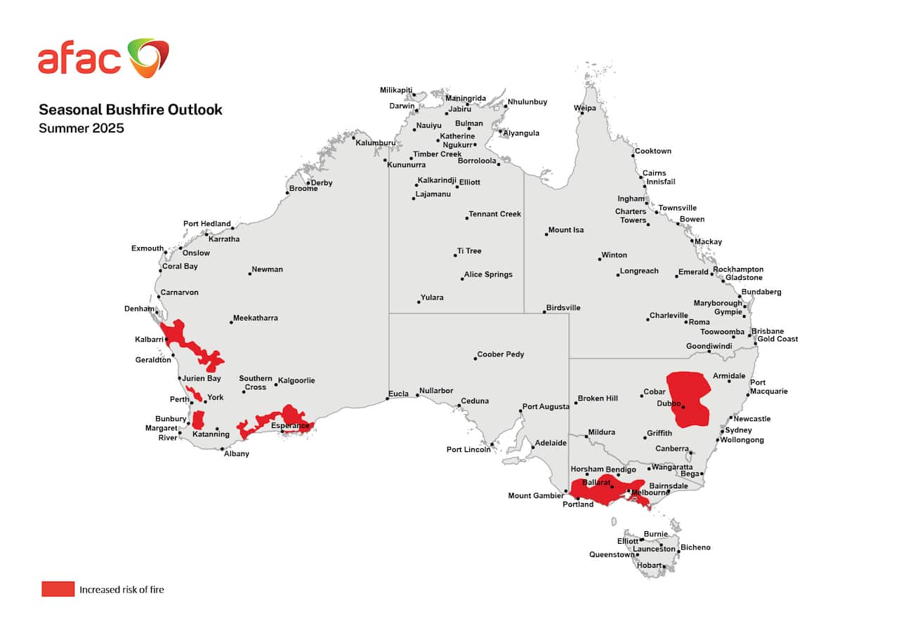
Despite La Niña remaining in place — typically bringing wetter, cooler conditions across Australia — no part of the country was assessed as having a below-average fire risk.
Instead, parts of western and southern Western Australia, central and northern NSW, and southern and central Victoria were identified as higher risk, while most of the country was assessed as facing normal risk.
Since the outlook was issued, bushfires have devastated parts of WA, NSW and Tasmania, resulting in several deaths and the loss of dozens of homes.
News that makes sense
Your trusted source for staying up-to-date with the world around you. Get free daily news updates and analysis, straight to your inbox.
It comes as other major weather events — floods in Queensland and a cyclone in WA — are also occurring.
Andrew Watkins, a research associate with Monash University's School of Earth, Atmosphere and Environment, said predicting this summer's fire risk was difficult due to competing influences from a weaker-than-usual La Niña and a Sudden Stratospheric Warming (SSW) event that started in September.
SSWs occur when temperatures high above Antarctica start to rapidly warm and are associated with warmer, drier conditions and an increased bushfire risk across Australia.
They are extremely rare in the Southern Hemisphere, with the only documented events occurring in 2002 and 2019 — both of which preceded devastating bushfire seasons.
Watkins said this year's SSW event likely contributed to warm, dry conditions across much of south-eastern Australia, with parts of it recording their hottest spring on record.
However, Australia is still in a La Niña phase, which he said could have contributed to torrential rain and flash flooding in north Queensland in recent days.
"For most of the year, we had a negative Indian Ocean Dipole, and we had approaching La Niña conditions and so that typically would give you an average to below average season," Watkins told SBS News.
But he said the competing influence of La Niña, the SSW event and climate change meant it was "not a typical bushfire year".
"It's never easy at the best of times, but this is a particularly tricky [bushfire forecast], with competing climate drivers both pushing things either way," Watkins said.
Rick McRae, an adjunct professor at the University of New South Wales, who has retired from a career in bushfires and emergency management, said 30 years ago, the Southern Oscillation Index — which tracks the development and intensity of El Niño or La Niña events — was a reliable indicator of bushfire seasons.
But he said other drivers, such as climate change, the Indian Ocean Dipole, and the Southern Annular Mode, were making fire forecasting increasingly difficult.
"Because things are so hot, the temperature anomalies are also influencing fire weather in a more localised pattern," he told SBS News.
"The oceans offshore from Australia are getting anomalously warm as well, and the balance between these things is altering the synoptic weather patterns," McRae said.
"El Niño is not necessarily the big kid on the block anymore, and increasingly, meteorologists and climatologists are having look at the range of these things.
"Whoever thought we'd look at Antarctica to know what our fire weather was going to be like."
Communities urged to stay vigilant
AFAC's executive director of national capability, Sandra Whight, said bushfires could still occur in areas identified as normal risk.
"You are still at risk [if] you live in a bushfire-prone environment, you need to be vigilant and ready and liaising and paying attention to warnings and keeping up to speed with the advice from your local authorities," she told SBS News.
AFAC's seasonal outlooks are developed with the Bureau of Meteorology (BoM) and state fire services and combine analysis of bushfire fuels, past rainfall, temperature and climate outlooks.
The BoM's latest long-range forecast, issued on 18 December, for January to March predicts a roughly equal chance of a wetter or drier three months for most of Australia.
Daytime temperatures are forecast to be above average across most of Australia, while overnight temperatures are very likely to be above average, with an increased chance of unusually warm nights in the northern half of the country.
For the latest from SBS News, download our app and subscribe to our newsletter.
